Thursday, May 24, 2012

Petition


Gateway Corridor is a light rail plan which may put a light rail train (or high speed buses) on residential streets like East 7th Street & White Bear Avenue.

Front yards should not be rail yards. The $1.2 billion, 25+ ton “light” rail train would run through residential neighborhoods, very close to several schools and hundreds of homes, and cut access to streets and businesses -- zig-zagging from Union Depot to E. 7th St. to White Bear Av., then down to I-94 and out to Woodbury. 

Putting a train on the streets doesn't leave room for traffic, parking, school buses, truck access to businesses, and puts a giant barrier across the Eastside of St. Paul.

Please sign a petition opposing Gateway Corridor (below).
►   If you like to walk or drive the neighborhood or have kids that walk across that path to school
►   If you are a business in the area and have heard what the Central Corridor has done to businesses
►   If you are concerned about light rail accidents when the train is placed in direct contact with homes and schools

Your information will be used for a petition opposing Gateway Corridor. It will not be sold or spammed by RIP Gateway Corridor.


  • Petition -- Opposing Gateway Corridor


  • Should be Empty:


Thanks to everyone who has signed.

New!  Here is another Gateway Corridor petition.

Spread the word. Here's a flyer:


Wednesday, May 23, 2012

Signs of Light Rail

 Once upon a time, this sign was the only sign a train needed.
 
 When did railroad tracks and a road become a light railroad?
There seems to be a progression of light rail development in Minnesota:
         -- from the Hiawatha Line running mostly along side of Highway 55
                   -- to Central Corridor running on University Avenue
                             -- to the Gateway Corridor fiasco running on residential streets -- by several schools and hundreds of houses. Running on their property!

What's next -- through houses, through schools, and through playgrounds?

It gets complicated. According to this sign, we can cross the tracks perpendicularly, but otherwise we have to drive along the tracks.
Is this sign telling us that the train is in the right lane or that we should be in the right lane? Which is it?

Do not drive on the tracks. That's clear. Except, how is the train to get anywhere if it can't drive on the tracks?
Do not be a passenger? Do not successfully cross in front of a train? What does this mean?


The rules of the road become far more restrictive with a train on it. No left turn. No parking. No buses. No trucks. Block driveway? There's no room to use a driveway. And many streets will be cut off. Remember, the priority is the train. Traffic lights will be added and will change for the train. Traffic congestion will need a decongestant. The traffic decongestant will cost another billion dollars.


Watch out for the train! If you think the train will always be on the right side of the tracks, don't bet your life on it. If you think your SUV will take the impact of a 25+ ton train, think again. You are no longer the monster truck of the road. You might as well be on a bike.

Children haven't been in many accidents yet, but that's part of the long list of problems with Gateway Corridor's plans for St. Paul. Weekday afternoons, kids walk home from school. That's the way things are in this part of town.

There is no way the train can travel slow enough to brake in time, especially on these sloping streets. Not for children, the elderly, the pets, or the wildlife.


Maybe they can just say no to pedestrians. Or children aren't allowed to live in the neighborhood.


Or have some sort of mandatory Train-Dangers Kindergarten for the neighborhood.


Light rail can't fund itself (for construction or operation) so its reason for existence is ridership. Except the Gateway Corridor project doesn't project having ridership. So its goals are anything. It is a tourist train -- see St. Paul's Eastside! It's a fast commute from eastern suburbs. It's a slow local train. And it's an economic development train, that will close existing businesses.
Beacon BluffingLight rail will run on the street.
Home Depot:      How will that help a Home Depot store? Will the train have a lumber-loading car?


All this for a relatively-quiet residential neighborhood. With trees.


Here comes the 25 ton (when empty) train. How quiet is it? How quiet are trucks? Ride the relatively-level Hiawatha Line through its turns. Then imagine the elevation-changing, zig-zagging Gateway Corridor train. Not quiet. Then imagine the trains and the tracks aging. Not quiet at all.

Light rail accidents happen. When the route is kept away from people and vehicles, there are fewer accidents. Accidents will be colossal if planners put tracks on residential streets.


But the signs will stop people from doing stupid things, right?


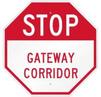
Stop Gateway Corridor.


"We talked about changing the T signs to M signs to represent Metro as in Metropolitan Council and Metro Transit. Well, a certain person from a certain Capital city said that M also stands for Minneapolis. That's the last time I bring cupcakes to a meeting, you know, the ones with the bright artificial-colored frosting? Some of those went flying like paintballs, marking everything and everyone. When the giant paintballs were gone, I found out that the T signs are TO signs, as in, 'I'm going TO somewhere' or 'I'm going TO get more cupcakes.'"


Tuesday, May 22, 2012

Gateway Corridor Nevermore


Quoth the raven: "Nevermore"

After that squawk, the raven continued:

"Nevermore will there be Gateway Corridor"

Take my front yard
turn it to a railroad yard
Take my front door
drop it as a station floor

Make my neighbor a convenience store

Buy off another as an ambassador

Commission a planning fool

To lay tracks small feet from school

tracks cross paths those small feet roam

and run by small feet from homes

Don't you know this means war

It's not like the trolley that came before

That was never a school class war

The gore, the gore, the gore

The train wasn't to blame, you underscore

It can't stop or steer; it's not responsible for

Four dead on the school bus; there might be more

The grief outpour...

Is that what you deplore?

Is that what you abhor?

Is that what you're sorry for?

Gateway Corridor.


Light Rail Ridership

There are certain unspoken and spoken rules about riding a light rail train.

The Light Rail Seating Rules:
1. Priority seats should be used by people with disabilities and senior citizens. They are located in the center of each train.*
2. If you sit in those seats, watch standing passengers to see if someone is in need.
          "You look old; you need to sit here."
          "I'm not as old as you."
          "You're older."
          "I'm not sitting there."
3. Don't put your feet up on empty seats.* 
4. Don't sit in the aisle seat when the window seat is empty.
5. Don't set belongings in an empty seat. Trains don't have spots for belongings, except bikes.
6. Don't slouch or cross your legs, making it difficult for people to get by you, says Chad in Denver.
7. Don't expect a seat. Light rail trains are not designed to seat everyone or even half the passengers. A full train is mostly standing passengers.

*  Announcements of rules 1 and 3 occur regularly when riding the Hiawatha Line in Minneapolis.

If the train is empty, I will sit. Otherwise, I stand, and I move out of people's way. That's my rule. Because to me, I don't care if a seat has a sign on it or not, if someone else should have a seat instead of me, I'd rather leave the seat empty than sit where they should be sitting. And I don't want to make a production out of offering my seat, so I stand. My rule, not others.


Houston has made the news for removing seats. Denver probably could too.

Minneapolis could remove empty seats too, most of the time. Driving empty seats around costs money. And when the trains are full... when leaving the Metrodome after a Vikings game, fewer seats could allow more people to pack in. Not pack as in the Packers...

Light Rail Riders
The Waterloo light rail advocates at Snapsort put together a humorously named infographic LRT For Dummies. Part of the graphic compares train and bus potential ridership by vehicle:

The funny thing is, I've never seen a train pass another train (going the same direction). And cars can't use train tracks when the train isn't there.

The Interstate 94 bridge between Minnesota and Wisconsin is now wide enough for car and truck traffic. Take away two lanes for a train. Trains could not compete with the potential traffic carried by the same two lanes, even if only cars drove in those lanes. The opportunity cost of the land (roadway, tracks... private residences) is the potential for mass transit (or otherwise), not the occupancy of vehicles.

Light Rail Advocates on Ridership

Ask light rail advocates if they use the train.
          "No, I wish! The train just doesn't go where I'm going."
          "No, I'm doing this for you."

Right. Not to free up the highway for themselves. They're doing this for me.

And for the Portland, Oregon coyote.


Monday, May 21, 2012

Light Rail News

As the Gateway Corridor light rail plans twist and turn through St. Paul in ways no railroad would design a track, it'll be a wonder if trains stay on the tracks. That's also a problem in Los Angeles.

Nortrak, a rail manufacturer, is arguing with Los Angeles on non-standard rail modifications to the Expo Line. The Los Angeles Times reports:

"The junction with its tight turn is a design that has never before been approved for MTA's passenger rail operations. The track intersection also does not conform to standards recommended by a national rail engineering group that sets design and construction guidelines for the industry.... The troublesome junction could, at least theoretically, increase the odds of a derailment should it contribute to a wheel failure or cause a train to jump the tracks at the Washington Boulevard turn..."

The story about flaws in the Expo Line is worth a read, in relation to the conceptual flaws of the Gateway Corridor.
==========
==========

Crime is up and down University Avenue. KAAL-ABC, Austin, MN reports St. Paul police say the number of people getting robbed on the street is up along the Central Corridor light rail route, typically at bus stops and on street corners. In the past month, more than half of all the robberies in St. Paul were on University Avenue. But the construction is causing the number of other crimes to go down. Police have seen a 22 percent drop in in shoplifting in April through June of 2012 because some businesses are harder to get to. Arrests for prostitution and gang-related activity are also down this year.

==========
==========

Light rail advocates claim the train will help the community, like the Rainier Valley in Washington.

Seattle's King 5 reports "light rail is driving up rent prices and driving out working class residents who are the lifeblood of the community."

==========
==========

Phoenix's KPHO-CBS reports 118 accidents for the new Phoenix light railroad since 2009. Of those, 22 drivers left the accident scene.


Friday, May 18, 2012

The Ups and Downs of the East Side

If Gateway Corridor light rail comes to Seventh Street and White Bear Avenue, it won't last.

It would take less than a decade to be torn out and even less than that to be called a Colossal Failure and a riderless menace to the public good.

The conceptual flaws start with putting a train on a residential street (35 mph in a 30 mph zone) with hills and valleys, and no effective stopping distance (essentially no brakes). The result would be accidents and deaths on a scale beyond the current level of light rail accidents.

Accidents and deaths aside, the system flaws will include:
       high costs & cost overruns
       low ridership & system inflexibility -- is it for commuting or touring or selling old 3M property?
       neighborhood barriers & business closings
        noise -- the rumbling of 25+ tons of train, the squeal of wheels on rails as it makes ridiculous twists and turns, the DING-DING chimes...

Light rail would scar the neighborhood. The neighborhood is still scarred from the trolley.

Drive Seventh, slowly. See the houses lower than the road? See the houses higher than the road? (Would you like to deal with the flooding issues and the lawn mowing issues?)

The slope of Seventh Street was changed for the trolley. It will have to be changed further for light rail. The trolley weighed nothing compared to light rail. Trolleys were light rail, more than light rail is light rail. Light rail is heavy.

Seventh Street is hilly, and it used to be hillier and wetter. The Mississippi River used to run through it.

Here's a topographical map of the East Side of St. Paul.

Notice how the railroads used river beds for their routes, instead of climbing bluffs and plunging into river valleys and climbing bluffs again, only to plunge back into valleys again, etc.


This map (above) shows a course of the glacial runoff, proto-Mississippi River #1, filling the Battle Creek valleys.


This map (above) shows a straighter-than-present-day, proto-Mississippi River #2, stretching north (along Etna & Barclay), connecting Lake Phalen (shown), Round Lake, Keller Lake, Gervais Lake, Kohlman Lake, then arcing eastward to Willow Lake, Gem Lake, Goose Lake, and White Bear Lake. Over time much of the proto-Mississippi River valley was buried in material, leaving behind a string of lakes and depressions (kettles).


This map (above) shows a zigzagging proto-Mississippi River #3 filling the Phalen Creek valley to Lake Phalen. This map does not mean to indicate that the areas between the proto-Mississippi River valley are high and dry. No. The neighborhood of Dayton's Bluff is porous with underground springs and sometimes above-ground springs.


This map (above) shows the path that the Gateway Corridor Commission likes to show as a potential light rail path. Notice how it drops from Union Station into the Phalen Creek valley (proto-Mississippi 3), then rises up Dayton's Bluff, then down to Earl Street, then up and down again (proto-Mississippi 2) and up to White Bear Avenue, then down to I-94, then down into the Battle Creek valley (proto-Mississippi 1), then up to Ruth Street and down again to Sun Ray shopping center to pick up groceries at Cub Foods and take them by train to Woodbury.


It's a ridiculous concept. The sanity of its planners should be questioned.

I question their loco motives.


Tuesday, May 15, 2012

Abrasive Advertising

The first step of advertising is a good name.

Gateway Corridor is in Cincinnati, Ohio and Greensboro, North Carolina and Seguin, Texas and might surround East St. Louis, Illinois. Since St. Louis is the Gateway to the West, the name makes sense, because East St. Louis would be the pathway (corridor) to the Gateway to the West.

In St. Paul, the idea of the Gateway Corridor is a meandering, roller-coaster train with a borrowed name, "rebranded and repositioned" by the Tunheim Partners.

They're confusing St. Paul with Minneapolis's Gateway Park (a.k.a. Skid Row or the Piss House). Or they think the Central Corridor is the gateway drug to the Gateway Corridor.


Here's the ups and downs of it. Starting at the Union Depot, the Gateway Corridor roller-coaster starts down a little (all roller-coasters do this), then it heads up (NE) to Mound,  then down (NW) to 7th, over the footings of the 1884 Seventh Street Improvement Arches (National Register #89001828), then up to 7th & Arcade and down to 7th & Earl, then up and up (E) to White Bear (Food Planet), then down (South) to I-94, and then up (East) to Sun Ray.

Committees, congresses, and commissions take reasonably educated people and turn their minds to something with the consistency of toxic waste. So the Gateway Corridor Commission (hopefully they aren't earning a commission on this) took the Gateway Corridor name from some other place and decided that commuting should be like a roller-coaster. Why?

Are they trying to park a train in front of Food Planet?

Or is the Gateway Corridor a way of selling off the old 3M property in St. Paul, the Beacon Bluff?

A St. Paul Port Authority committee thought up the name Beacon Bluff. The 61-acres that had been the 3M headquarters (1910-1962) had manufactured Scotch tape and sandpaper, but the committee couldn't use 3M Land or Scotch Tape Fields without risking trademark infringement lawsuits. The land lies near Dayton's Bluff and had been used to make beacons, so since it was late in the day and people were hungry, they decided on Beacon Bluff.

The ad for the property shows an aerial view of the struggle to get trucks to an interstate. Beacon Bluff is on the far right. Trucks take the steep 7th Street hill down to I-94, not that that would get goods moving east-bound, or trucks can take Phalen Blvd. to I-35E, not that that would get them south-bound. The ad covers over the Dayton's Bluff neighborhood with a closeup of the property, since the neighborhood doesn't provide any direct transportation route. The only thing that could make trucking worse would be to plant a passenger train in the middle of the road.

Wait. There's more! The St. Paul Port Authority wants to make Beacon Bluff a shrine to 3M with monuments to sandpaper --

and outdoor tape dispenser lounge chairs --


Careful, that's the double-sticky chair!

And a shrine is fine, except for the inconsistency that somebody left toxic chemicals behind --


and the neighborhood is one of St. Paul's poorest. How will a 3M shrine give jobs to the area?

But then again, how would a Gateway Corridor roller-coaster and light rail line help the neighborhood to get jobs at any businesses that fill the Beacon Bluff? Or is that the bluff?

Beacon Bluff is a marketing plan in St. Paul for the old 3M property that some people think would sell better if a light rail roller-coaster (Gateway Corridor) went by it.